Creating an alternative map on Google Earth was likely the most productive and personal project for me that we have done this semester. I enjoyed being able to produce a navigable online space of what is truely my home in the world that can be accessed and perused by other students at the college, as well as my friends and family members. The tools that Google Earth provides allowed me to fully customize the map that it would reflect the unique narrative and exploration I wanted to provide for viewers (even if I was unaware of some of the tool that could have potentially enhanced this personalized and directed view of campus at the time of making the map.)
After transfering to St. Mary's, the campus has been the one place on Earth I can truely call home at this point in my life, and there are a number of spaces that hold memories and emotions for me that are not reflected in the actual environment. It was fulfilling to be able to locate and present my memories in a visual way on a space that reflected the reality of the geography of campus as a means of digitally imprinting my impact onto this campus. I was also particuarilly thrilled to see how my own experiences and places of importance overlapped with the sites chosen by other students in the class - it allowed me to more fully realize the history and presence each site on campus has that cannot be realized in merely viewing photographs or looking at the spaces from afar.
Google Earth does have its limits, but I appreciate the online interactive aspect of the maps that we created for this project. Rather than only having my own experiences imprinted onto the space, Google Earth provides a venue through which spaces and projects can be overlapped in order to showcases the enormity of influence this environment has that cannot simply be represented on a state or governmental map.
Monday, May 11, 2009
Artist Category Week 13: The Walker Sculpture Garden


The Walker Sculpture Garden, 1998
The Walker Sculpture Garden is an interactive map run through Cosmo Player that provides a virtual reality tour through the VRML Minneapolis Sculpture Garden. Viewers move through garden pathways where they will encounter icons that leads them to further information and images of the sculptures in the garden. The project was designed to be an exploration of the possibilities of Web-based 3D environments.
This project seems to mirror many of the function of Google Earth that we utilized for a our final alternative mapping project. The site presents a digital space mapped out to represent an actual environment in nature. As we added icons or small tacks into our Google Earth map, the Walker Sculpture Garden makes use of the above icons to identify for users areas of interest that can be explored more thoroughly. Like the placemarks of Google Earth, these icons can be clicked on to bring up information in the form of text that describe the sculptures as well pictures and other media that allow viewer to interact and engage with the visual aspects of the pieces.
This project seems like an interesting and difficult endeavor due to the three dimensional nature of sculptures. It is one thing to provide what could almost be considered a travel brochure of campus through a particular lens definied by each student in our alternative maps - we were not attempting to engage viewers in the actual space of our map, but instead provide a mental and intellectual journey through a particular series of interconnected locations. Sculpture is obviously three-dimensional in nature, so to only display photos or revolving images of the pieces does not provide an accurate experience of the work. The online project also seems counter-intuitive to the physical reality of a sculpture garden. The sculpture gardens I have visited have been engaging and worthwhile for the full sensual experience they provided - there was sights, sounds and smells produced by the wildlife, but there was also the spacial dimension of moving in and around the sculptures in a physical environment that allowed me to fully immerse myself in their presence. Viewing these works online in what might be called a glorified and complicated slide show does not do justice to the true experience such works have the potential to convey.
Thursday, May 7, 2009
Artist Category Week 12: Sensitive Rose

Sensitive Rose, Martha Gabriel
Sensitive Rose is a mobile device based artwork designed by Marth Gabriel and commissioned by the Turbulance website. The device is loaded onto a mobile phone or PDA, where users are able to input their wants and desires and as they add information the compass rose is altered to react to and pinpoint these desires. An example would be, "Mark wants love" which would then be responded to based on an information network that tracks the desires and wants of other users of Senstive Rose.
This piece, for me at least, is slightly terrifying in the way it depicts how dependent we have become on moblile devices - phones, PDAs, Ipods - as a means of locating ourselves in the world and communicating with other human beings. It is one thing to ask a device how to reach a defined building or city, or where to travel in order to reach the nearest Italian restraunt. Sensitive Rose plays with the idea that in the future we could become so dependent on our electronic paraphenalia that we could find love, or success, or happiness through the click of a button. Sensitive Rose is also an interesting project to study during our phsyiogeometry segment of the class because it displays the variety of places, objects, and ideas that people wish to map and locate. It is easy to place on a map where one can find food or shelter, but to map out a path to broad concepts such as "love" is such a personal mission that it seems almost impossible to pursue. However, because these concepts are so based on a common human connection, a program such as Sensitive Rose seems apt for attempting to locate them because it is so user driven and based on the common desires of humanity.
As a side note, the project is also disterbingly similar to online dating sites such as E-Harmony. While this may not have been the artist's intention, the link is there and it just goes to show how people have latched onto the idea that the internet, satelites and online devices can be relied on by certain individuals for locating anything these days.
Artist Category Week 11: Eclipse
Eclipse is a project produced by the EPA that takes United States national and state park images on Flickr.com and altars and corrupts the images based on real-time data from the Air-Quality Index. The algorithms that are defined by this data appear as lines of saturation, color, and contrast over the face of image that are designed to represent levels of pollution in these areas based on the output of nearby cities.
Eclipse is a type of digital mapping project that involves both personal experience and political initiative. By using civilian imagery of these parks, drawn from the free and open Flickr website, visitors are exposed to images that are infinitely more identifiable to their own experience than government produced maps. By using these images to display their message and initiative, the EPA is working to involve ordinary people in a project that might otherwise be dismissed as propaganda. Like previous works I have looked at, this project showcases the overlap between art and science that is a major factor in many works of Digital or New Media artwork. The images produced may be considered "art" and can be analyzied for their visual impact, but the message lies in the scientific data that defines and creates these pieces. The issue of copywright and authorship is also present in this work for the fact that the EPA is using images that they have no claim over as a way of involving visitors on a more personal level, and for the fact that the pieces produced are not the result of any aesthic vision but are more a chart or graph overlayed onto a static image.
I believe this work showcases one of the more intreging aspects of New Media Art - where and how do we draw the line about what is art and what is just information and visual data? I'm not sure the EPA intended their project to be considered artwork, but they certainly appealed to that impulse in human nature as a way of drawing more users to their cause and creating a more stricking visual image that would hopefully motivate cititizens to become active in combatting pollution when they see it affecting their own personal view of the landscape.
Wednesday, May 6, 2009
Mapping/Psychogeography Reading Response
The episode of This American Life that dealt with the subject of mapping was engaging and sparked my imagination on the endless amount of content that can be "mapped". I think the most relevant aspect of the visual mapping that was done by the cartographers who were interviewed during the segment was the basic principle of mapping that they adhered to: focus on only the aspect you are mapping and remove any excess content from your map. For instance, one individual was mapping the spaces where people put out pumpkins on their porches during Halloween, but he included no other information about streets, houses, or any indications of what made the area a neighborhood. In this way he was able to construct an image that was physically mapping something that existed in reality, but it also served as a narrative - a story about people and pumpkins that could only be told through that lens.
More useful to me for my own alternative map was the idea of charting experiences that were not visual. The segment went through and identified different individuals who created maps based on sounds, smells, touches and tastes. Each person was not necessarily mapping these senses for practical and functional purposes but more so as a way to record their own memories and experiences in an environment. This potential of mapping - to record experiences that may or may not exist any longer but are none-the-less tied to and associated with certain spaces - led me to my own theme for the mapping project. I, too, wanted to map something that was beyond the physical visual realm and decided to trace places of transformation that may be physical, mental or spiritual, transient or permanent, but spaces that contained a memory of stepping beyond my own experience as a college student and adopting roles that allowed for alternative experiences.
More useful to me for my own alternative map was the idea of charting experiences that were not visual. The segment went through and identified different individuals who created maps based on sounds, smells, touches and tastes. Each person was not necessarily mapping these senses for practical and functional purposes but more so as a way to record their own memories and experiences in an environment. This potential of mapping - to record experiences that may or may not exist any longer but are none-the-less tied to and associated with certain spaces - led me to my own theme for the mapping project. I, too, wanted to map something that was beyond the physical visual realm and decided to trace places of transformation that may be physical, mental or spiritual, transient or permanent, but spaces that contained a memory of stepping beyond my own experience as a college student and adopting roles that allowed for alternative experiences.
Artist Category Week 10: eMPire of sIGns
 Philippe Vergne, eMPire of sIGns 1998
Empire of Signs is a project produced by Walker Art Center Visual Arts Curator Philippe Vergne as a way to document his 1998 five week trip through Japan. Through a combination of sights, sounds, and symbols Vergne attempted to create a digital space that would guide viewers through his experiences in Japan as he was researching many of the artists in the exhibition Let's Entertain. The project is introduced as a "hyperessay".
The structure of site, while a little more chaotic than many travel blogs, mirrors the setup that tourists now have at their disposal in order to document their time in foreign environments. The accessibility and proliferation of video and audio software makes it exceptionally easy and convenient for anyone to recreate the progress of their own travels. While in the past, people might have had to actually leave their house in order to experience new environments, the multiplicity of travel logues makes it exceedingly possible to gain a personal perspective of other places from the screen of the computer.
What intreguies me about Vergne's project is that, while he does include text on certain pages, the majority of the website is navigated through signs and symbols. It may represent a view of Japan, but through the construction of the site Vergne has created his own new personal environment that can only be experienced through the website - no other person would have this exact experience in a real space. He is also mapping his own memory in a fashion by using symbols to represent different experiences and conceptions rather than actual real objects and buildings.
Thursday, April 23, 2009
Artist Category Week 9: Apartment
Apartment, Marek Walczak and Martin Wattenberg
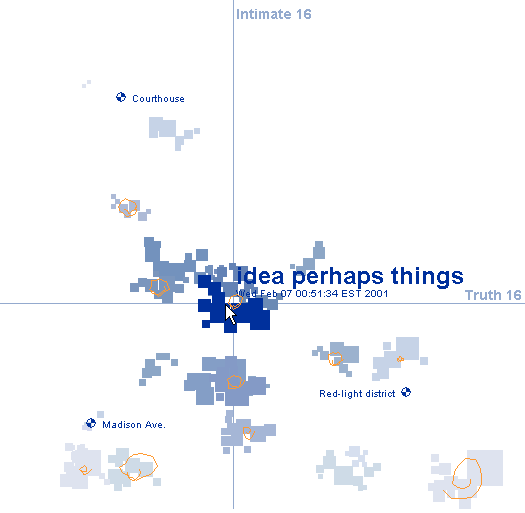
Apartment is a program designed by Marek Walczak and Martin Wattenberg that constructs spaces based on the text input from viewers. Visitors are confronted with a blinking cursor and as they begin to type rooms take shape in the form of a two-dimensional plan, similar to a blueprint. The program is able to recognize semantic connections in the visitor's type and then connects them based on theme. Buildings and cities are clustered according to their linguistic relationships.
Apartment seems to be based on a tenant of phenomenological philosophy - that spaces are definied by memory and language and we construct them in our minds not based on dimensions or physical properties but on the memories and ideas that we associate with them. The project almost seems to be an attempt to essential map our minds - to discerne how our different patterns of thought can be translated into a visual component.
The project envisioned by Walczak and Wattenberg can be concieved of in a similar vien to the type of alternative mapping we are exploring in class, but structured in an opposite formation. Rather than going out into an actual environment and distinguishing between different elements that physically define the space, Apartment instead takes our own mental patterns, a purely intellectual pursuit that have no concrete manifestation, and constructs an environment that is definied by their relationships. The element being mapped is then our own trains of thought and their intersticies, and the environment in which these elements are located is a visual representation of our own conciousness.
The ideology behind the project is imaginative and enaging, although its practical implimentation through the programming designed by its creators seems to be limited in constructing a project of the scope imagined. Computers, fortunately, are not yet people, capable of the intricate process of connotation and autonomous linguistic patterns. While Walczak and Wattenberg may have created a comprehensive database of the english language based on definition, it seems impossible to fully express the enormous amount of associations contained in each individual word or to take into account the matter of individual interpretation. The program is tremendous for its potential to create a primitive landscape of the mental realm, but at this current stage I do not think there is the technology available to fully map the mind. I truely hope that day never is realized either, because I dread the thought that all the enormous power of the human imagination can be reduced down to a code that can be read through a computer.
Subscribe to:
Posts (Atom)